Information Center
- Main page
- Information Center
- Government News
Government News
- Source
- korea.net
- Date
- 2024.11.28

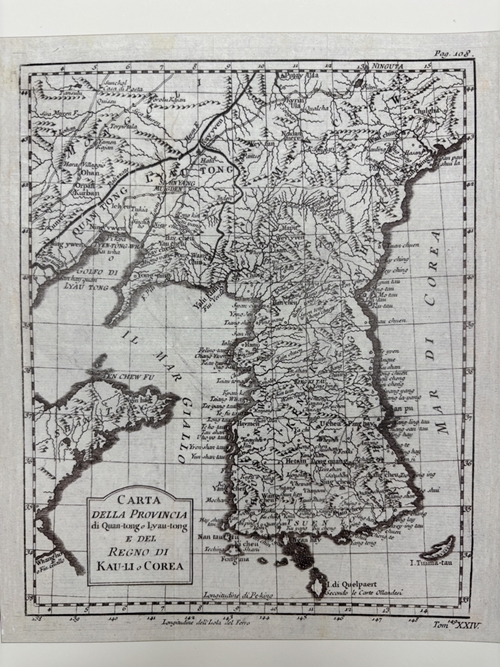
This is the Italian version of Carte de la Province de Quan-tong ou Lyau-tong et du Royaume de Kau-Li ou Coree (Map of Quantong or Liandong Province and Kingdom of Joseon), a map of Korea produced in 1750 by French cartographer Jacques Nicolas Bellin. (Northeast Asian History Foundation)
By Lee Dasom
A European map from the 18th century recognizes Dokdo Island as Korean territory.
Dokdo Museum Seoul at the Northeast Asian History Foundation in Seoul on Nov. 26 said it chose the Italian version of Carte de la Province de Quan-tong ou Lyau-tong et du Royaume de Kau-Li ou Coree (Map of Quantong or Liandong Province and Kingdom of Joseon or Korea), a map produced in France in 1750, as the museum's "Old Map of the Month."
Made by French royal hydrographer Jacques Nicolas Bellin, the map clearly marks the islands of Ulleungdo and Dokdo and the Sea of Korea (now the East Sea).
Bellin's display of the Korean Peninsula closely mirrors that of the French geographer Jean Baptiste Bourguignon D'Anville's Royaume de Coree (Map of Joseon Kingdom). The former map has the border between Joseon and the Qing Dynasty of China is tilted north, similar to the latter, and the area east of the Tumen River including Nokdundo Island is also labeled Joseon territory.
Ulleungdo is marked as Fang Ling Tau, Dokdo Chiang-san-tau and the East Sea Mer di Corea.
The museum through Dec. 31 will display the map at its Dokdo history corner.
dlektha0319@korea.kr